12. Geolocation settings
The Geolocation section defines how the world map gets rendered in the Geolocation view and the Previewer’s Geolocation tab.
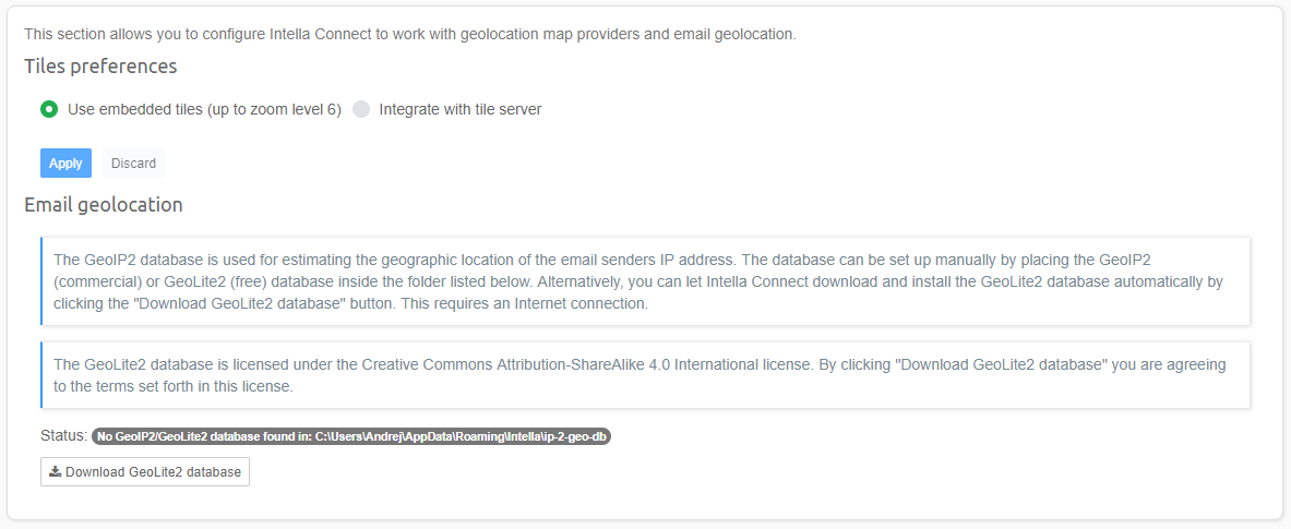
Intella Connect embeds a set of tiles for rendering this map. By default, this tile set is used. This embedded tile set enables use of the Geolocation views without requiring any configuration and/or network connection. The drawback of using this tile set is that the user can only zoom in six levels.
Another option is to integrate with a custom tile server. To enable use of such a server, select the Integrate with the tile server option. The Geolocation section will then expand to offer additional settings.
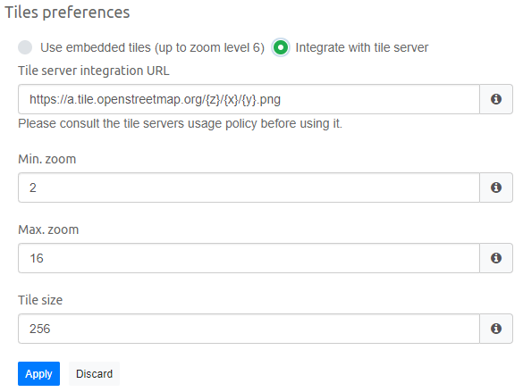
In the example above, OpenStreetMap’s tile server is used. You can use any tile server you wish by typing its address into the Tile server integration URL field. The format for the URL is dependent on the chosen tile server.
Note
Note that to use a public tile servers, you need to ensure that you comply with the tile server’s usage policy. This is your responsibility, not Vound’s.
The Min. zoom option defines the desired minimum zoom level in the user interface. This should be in the range of supported zoom levels of the chosen tile server.
The Max. zoom option defines the desired maximum zoom level in the user interface. This should be in the range of supported zoom levels of the chosen tile server.
The Tile Size (pixels) option defines the size of a single square tile. This value should match the size of the tiles which are returned by the tile server.
If the tile numbering order used by the tile server is reversed, then this must be reflected in tile server URL with minus sign,
for example https://a.tile.openstreetmap.org/{z}/{x}/{-y}.png
Note
Important: Using a public tile server may reveal the locations that are being investigated to the tile server provider and anyone monitoring the traffic to that server, based on the tile requests embedded in the retrieved URLs.
Note
Tip: If the investigation system has no internet connection, a custom tile server can be set up on the local network. One way of how this can be achieved can be found at http://osm2vectortiles.org/docs/serve-raster-tiles-docker/. This is out of the scope of this manual and Vound’s technical support.
Email geolocation allows one to estimate the geographic location of an email’s sender using the sender IP address. This process takes place during indexing. The process and its caveats are described in Activity view.
Determination of the geographic location of an IP address requires the presence of MaxMind’s GeoIP2 or GeoLite2 database. These databases associate IP addresses with geographic locations. The databases can be found here:
- GeoIP2 database (commercial) – https://www.maxmind.com/en/geoip2-city
- GeoLite2 database (free) – http://dev.maxmind.com/geoip/geoip2/geolite2/
See the MaxMind website for a description of their differences, beyond price.
The chosen database can be installed here by placing it in the following folder:
C:\Users\[USER]\AppData\Roaming\Intella\ip-2-geo-db
Alternatively, when you are on an Internet-connected machine, you can let Intella Connect download and install the GeoLite2 database automatically by clicking the Download GeoLite2 database button. After clicking this button, the download will start. The download progress will be shown in the Status field. Once the download has completed successfully, a green validation message will be shown here.
Important
To use the Email geolocation feature, check the Determine the geographic location of an email sender’s IP address option when adding a new source.